
Drone Mapping & Aerial Data Services in Wisconsin
High-resolution aerial mapping and photogrammetry for commercial properties, industrial sites, redevelopment projects, and professional project teams
Milwaukee-based • Serving Southeastern Wisconsin and projects statewide
OBJECTIVE GEOSPATIAL INFORMATION
Measurable Aerial Mapping for Real-World Sites
Aerial photography documents how a site looks. Drone mapping creates spatially registered information that can be measured, analyzed, and incorporated into project workflows. Overlapping aerial images are processed through photogrammetry to produce a high-resolution orthomosaic—a geometrically corrected, map-based representation of the site rather than a collection of individual photographs.
Depending on project requirements, the same aerial dataset can support surface and terrain models, contours, elevation visualization, measurements, and other derived information. Deliverables can include georeferenced imagery and GIS-compatible data for use in existing software, or project-specific interactive maps that make detailed site information accessible without specialized geospatial software.
The result is not simply an aerial view, but a measurable and reusable record of site conditions.
ACTUAL PROJECT • SOUTHEASTERN WISCONSIN
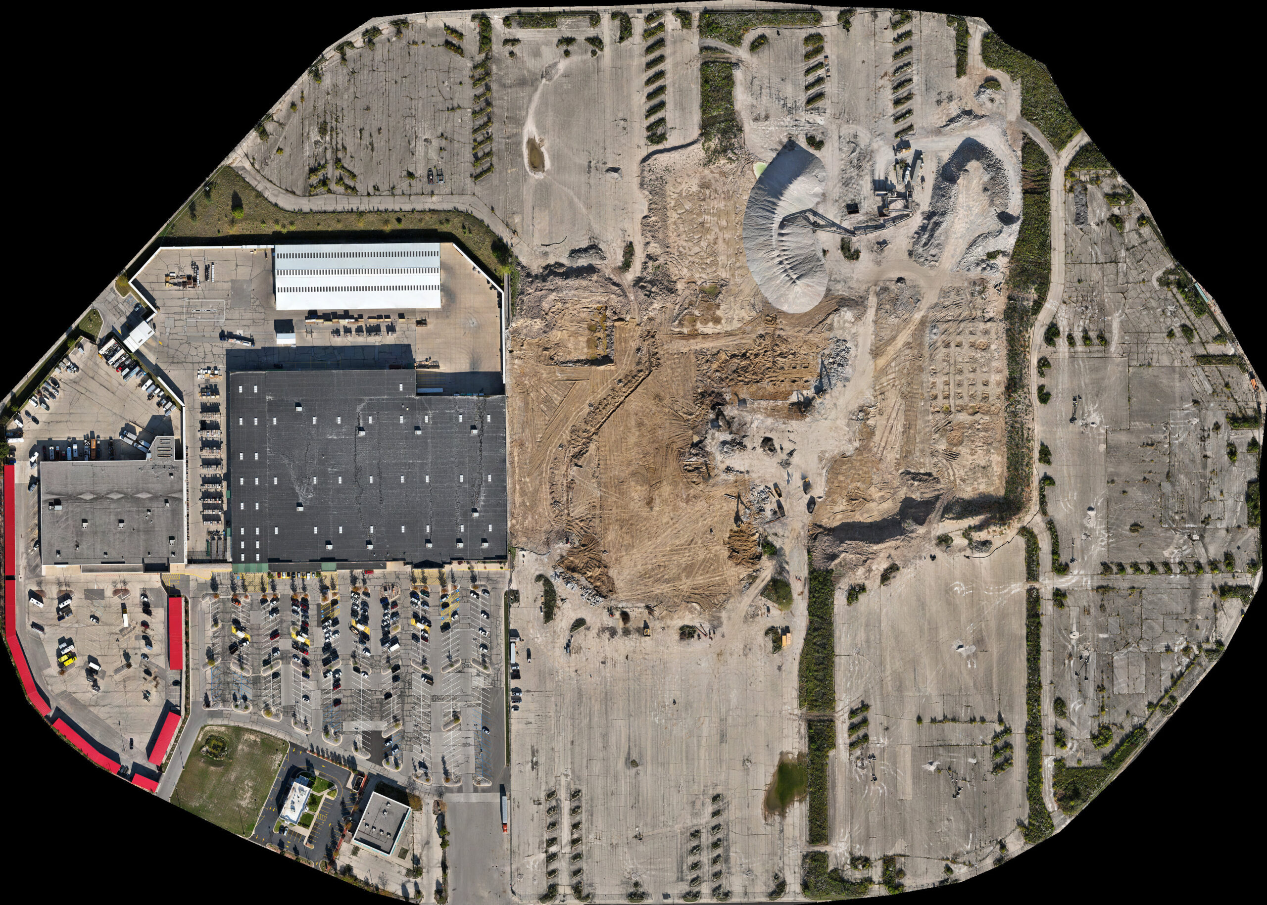
Explore an 85-Acre Interactive Drone Map
This approximately 85-acre Milwaukee mapping project demonstrates how high-resolution aerial data can be delivered as an interactive site resource. The full project viewer allows users to inspect site detail, navigate across the property, take measurements, and view available project layers at multiple scales.
PROJECT INSIGHTS
What Questions Can Objective Mapping Help You Answer?
Every property presents unique questions. Objective, measurable aerial documentation helps owners, engineers, and project teams understand existing conditions, evaluate assets, monitor change, verify completed work, and make informed decisions throughout the life of a property or project.
COMMON APPLICATIONS
What Drone Mapping Can Support
Construction sites, redevelopment projects, commercial properties, industrial facilities, solar installations, and landfills each present unique documentation, inspection, and mapping requirements. The examples below illustrate common project environments where aerial data collection and measurement-capable deliverables provide value.
UAS FIELD ACQUISITION
Wisconsin UAS & Drone Data Acquisition for Project Teams
Altravar provides local UAS field acquisition for engineering, environmental, architectural, surveying, and other professional project teams. When internal UAS resources are committed elsewhere, or when deploying a client’s staff and equipment to southeastern Wisconsin is inefficient, aerial data can be collected to client-defined project requirements and delivered for use within existing photogrammetry, GIS, engineering, inspection, or documentation workflows. Field acquisition can be provided independently or paired with processed mapping deliverables when required.
Client-Specified Acquisition
Work from client-defined areas of interest, flight parameters, capture specifications, control requirements, and established project protocols. Repeatable acquisition can be configured for recurring or change-documentation assignments.
RTK-Capable Collection & Source Data
DJI Mavic 3 Enterprise with RTK capability supports consistent, spatially referenced aerial data acquisition. Organized source imagery can be delivered for use within existing photogrammetry, GIS, engineering, inspection, or documentation workflows.
Local & Controlled-Airspace Operations
Milwaukee-area field acquisition provides a local resource for Wisconsin project teams, including controlled-airspace assignments requiring FAA authorization beyond available automatic-approval limits.
Professional-services boundary: Where licensed professional services are involved, Aeroscope’s role can remain limited to aerial data collection performed to the project team’s requirements.
DISCUSS YOUR PROJECT
Let’s Discuss Your Project
Every project begins with understanding your objectives. Whether you’re documenting a commercial property, monitoring redevelopment, evaluating site conditions, or inspecting facility assets, Altravare provides objective, measurable aerial documentation tailored to your project’s requirements.
Based in the Milwaukee area, Altravar provides drone mapping, aerial data acquisition, and property documentation throughout southeastern Wisconsin, with availability for suitable projects statewide and beyond the immediate region.

FAA Part 107 Certified • Insured Commercial Operations • RTK-Capable Acquisition • Controlled-Airspace Authorization Experience